Google have been recording the location of my android phone every time it talks to their servers for the past year. It talks to their servers a lot.
Locations I (or rather my phone) have been in Colorado:
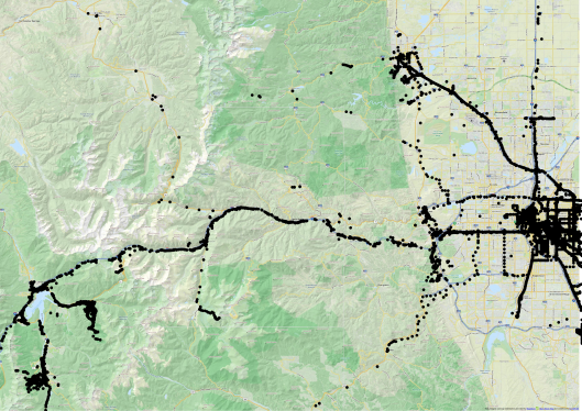
23 Monday May 2016
Posted in Geo data
Google have been recording the location of my android phone every time it talks to their servers for the past year. It talks to their servers a lot.
Locations I (or rather my phone) have been in Colorado:
13 Friday May 2016
Posted in Geo data
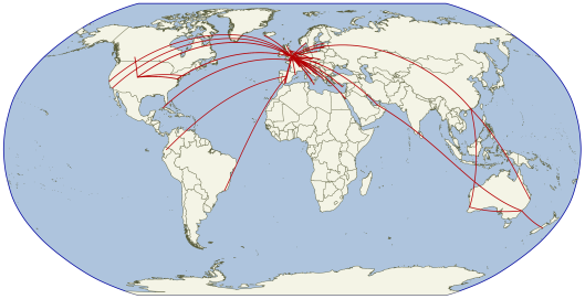
To celebrate my 100th flight (DCA to DEN, as you ask), here’s an update to my flight map.
06 Monday Jul 2015
Posted in Geo data
The relative sizes of Colorado, New Zealand and the United Kingdom.

08 Monday Jun 2015
Posted in Geo data
To overlay two countries, move them so that their centres are over the same point (eg 0, 0). The trick is to make sure that they stay the same size, and don’t get too distorted in the process.
The jamegeo.com country comparison method is:
1. Re-project your country into a UTM zone. This means that you can translate (move) it North or South without enlarging / shrinking the country, or distorting the shape. This only works if your country fits inside one UTM zone… which almost none do.

Step 0: Choose your country (or in this case some of a country)

Step 1: Re-project your data into a UTM zone and move it South until the centre is over the Equator.
2. Move the country until the centre sits on the equator. Expect minor change in shape if your country is too fat for its UTM zone.
3. Re-project into a Equirectangular projection (eg WGS84)

Steps 2/3: Put your data back into a rectilinear projection (eg WGS84). Note that CONUS appears to have shrunk, as this projection emphasises size near the poles. Some distortion has occurred because CONUS does not fit into one UTM zone.
4. Move your country along the equator, which you can do in a equirectangular projection without altering the shape.

Step 4: Move your shape East until it is over (0, 0). You can do this in WGS84 because there is no distortion along the Equator.
5. Rescale (a very little bit) to compensate for any shrinking during stage 2.
6. Combine with another country and be very pleased with yourself.

Testing with Greenland, New Zealand and the Congo.
25 Monday May 2015
Posted in Geo data
Tags
Which is bigger, Australia or USA?
By USA we mean the contiguous states.
I forget who asked, but judge for yourself!

Continental US and Australia comparison by jamesgeo.com. Released under Creative Commons Share-alike license 4.0 Countries modified from thematicmapping.com
This construction image has a certain elegance to it:

Construction method (CC license as above)
11 Monday May 2015
Posted in Geo data
Tags
We’ve previously seen that our Air Safaris Scenic flight was close to the advertised flight path. To add some 3D information I’ve found a 8m DEM.

DEM showing higher areas as white, and lower as black. Scenic flight in red. DEM data provided by Land Information New Zealand under NZ creative commons license 3.0
I’ve used the QuantumGIS 2threejs plugin to show the side view – both the flight and terrain data are now in three dimensions.

DEM data provided by Land Information New Zealand under NZ creative commons license 3.0
Now that we have a DEM, we can drape any imagery over the top.

Air Safaris promotional brochure draped over LINZ DEM.

Google maps imagery draped over LINZ DEM.
27 Monday Apr 2015
Posted in Geo data
Imagine there’s no countries.
It isn’t hard to do.
Imagine unioning all of the countries (turning all of the separate shapes below into one) … it turns out to be harder than I thought.

Original data – lots of countries in the original projections (WGS84). This an other images on the page by jamesgeo.com Released under Creative Commons Share-alike license 4.0 Countries modified from thematicmapping.com

Attempt 1: st_union(geom) – this created one big shape, but with lots of little bits of borders

Attempt 2: st_union(st_makevalid(geom)) – this removed some of the internal borders, but it still looks pretty rubbish.

Attempt 3: st_union(st_snaptogrid(geom, 0.0005)) – this forces the individual shapes to be part of a grid, compensating for slight errors in the original data.

The world in Bonne projection. I think John Lennon would like that.
Which brings to mind a favourite saying of another Beatle:
Peace and love,
Peace and love
Thanks, Ringo.
30 Monday Mar 2015
Posted in Geo data
Tags
In February Jamesgeo Team NZ flew on Air Safaris’ Grand Traverse and took lots of photos. For the record, this was an excellent experience. The Air Safaris guide shows the proposed flight path… but where did we really fly?

Screenshot of Air Safaris ‘Grand Traverse’ from guide
I have used QuantumGIS’s georeferencer plugin to turn the above image into a map by identifying a number of Ground Control Points (GCPs), such as Lake Tekapo airport, Glentanner Park and various road junctions. This results in a georectified (and georeferenced) image, displayed in WGS84, the coordinate reference system of the GPS points used as the GCPs.
 Step 2: Ingest GPS points into database
I made a new postgreSQL table with columns for both 2D and 3D geometries, then inserted each point (see bottom of page for SQL commands). This gives us 1410 points, coloured here by altitude. I have reprojected the map into the New Zealand map grid (EPSG:27200).

Displaying this route on top of the Air Safaris map:

So our blue track is pretty close to the advertised red track. Well done Air Safaris!
16 Monday Mar 2015
02 Monday Mar 2015
Posted in Geo data, Populations

The world in 10 sections by jamesgeo.com. Released under Creative Commons Share-alike license 4.0 Countries modified from thematicmapping.com

